 Here is a pic from September, when I first went up the "Teleferico", the cable car which takes its passengers to just over 13 thousand feet.
 That weekend that weather was REALLY cold (note the snow!--- which is very rare here, even at this altitude). The weather was only one of the reasons I didn´t climb the mountain that weekend.
This time, I once again rode the Teleferico. I met some other hikers, two from the US, two from Germany and one from Quito. We all took one of the first cable cars to the start of the trail (9am). The two guys from the US, Kalon (Mississippi) and BJ (Kentucky), let me join them in their trek to the top of Rucu Pichincha. Here´s a pic of Kalon and BJ.
 Although Rucu (old one) Pichincha is not as tall as GuaGua (Baby) Pichincha, the hike is longer. Apparently you can almost drive to the top of Guagua- which is the still active, growing peak of the Pichincha Mountain (Volcano). Here is a pic of the Guagua crater from Rucu peak.
 Guagua erupted in 1999 and Quito was covered in ash. It is expected to erupt again someday, but it will erupt in the direction away from Quito.
 Here is a pic of the Rucu peak taken from the trail. The surrounding landscape is called "paramo", and is found in Ecuador, Peru, Colombia and Venezuela at 12 thousand to 14 thousand feet. It is characterized by low-lying plants and bushes and plants with amazing adaptations to the high altitude, strong winds, cold, the extreme sun and the often cloudy climate.
 Here is a really cool low-lying plant that covers some rocks ... I remembered it from trekking through the Andes in Peru as well.
I kind of feel like a smurf while traversing land coverings like this!
 These beautiful flowers covered some of the hillsides and the plant´s leaves have a waxy, protective coating. As the flowers mature they turn into wind-blown distributors of seeds, similar to dandelions.
 This plant, above, I originally thought was covered in spider webs. However, the cobweb like substance is actually part of the plant and appears to be a protective coating from either plant-eating animals or the harsh climate.
 The hike to the summit lasted between 3 and a half and 4 hours. The primary trail splits for the last hour and a half of the climb into two trails: one that apparently includes thrills and chills and maybe you should have ropes for... and the other, which I did, involved a bunch of steep trails on sand. Kalon decided to try the more adventurous-deadly route and BJ and I opted for the difficult but soft-landing route.
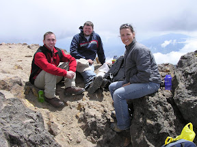
We all made it to the top at about the same time. Here we are at 15,100+ feet.. we arrived around 1:30pmish and stayed until 2:30pm when the clouds began to accumulate and the temperature dropped.
On the way back down we noticed these beautiful purple flowers (below) that we hadn´t seen before. Behind the flowers on the hillside are what appear to be some sort of containment barriers (to prevent erosion? transfer water flow for other use?).
 They are not modernly used for anything and although upon first glance I thought they were part of a city project to prevent erosion, closer inspection proved that they were quite old. The Quiteño we asked said that there are many "stories" about where they came from... including that the aliens brought them!
| From |

1 comment:
Se ve todo fantastico, me hubiera encantado ir contigo a todos esos lugares...
Y hacer cosas q tu haces..
Post a Comment